I wore five smartwatches to the top of Mount Diablo. These brands were best for elevation accuracy
Last weekend, I strapped on five fitness smartwatches, drove to Mount Diablo State Park in California, and hiked about 2,100 feet to the summit. For what? Deciding which smartwatch brand – Apple, COROS, Garmin, Polar or Samsung – was most accurate for altitude tracking. Most high-end smartwatches come with a barometric altimeter to gauge your […]
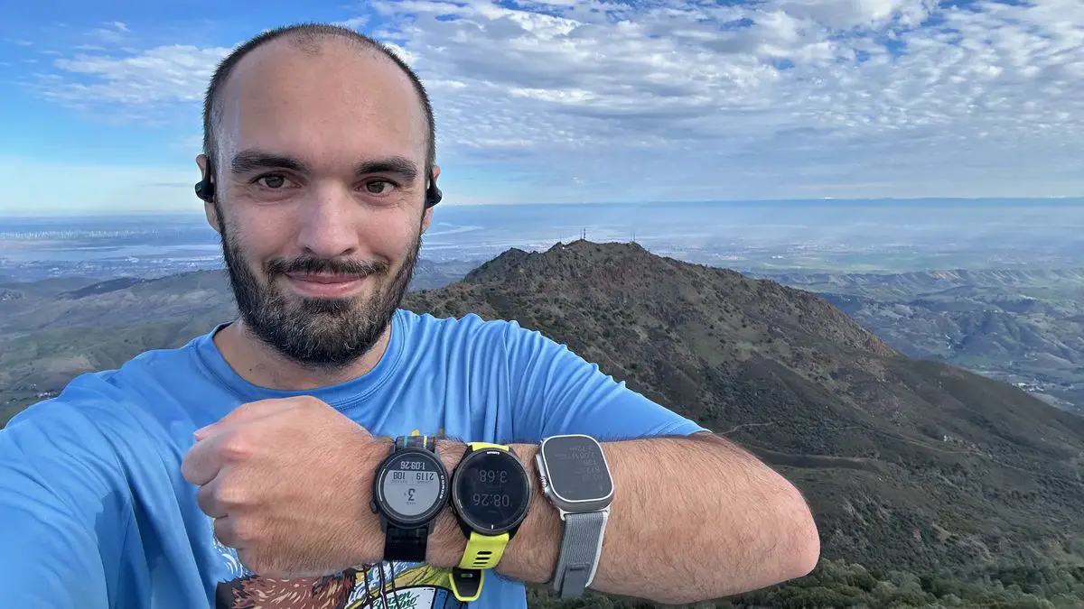
Last weekend, I strapped on five fitness smartwatches, drove to Mount Diablo State Park in California, and hiked about 2,100 feet to the summit. For what? Deciding which smartwatch brand – Apple, COROS, Garmin, Polar or Samsung – was most accurate for altitude tracking.
Most high-end smartwatches come with a barometric altimeter to gauge your elevation gain during outdoor workouts. Altimeters use changes in air pressure to calculate changes in altitude in coordination with GPS data. But some are more accurate than others, and most brands don’t let you manually calibrate your starting position.
I’ve wanted to test this for a while, ever since my experience last year when I wore six smartwatches for 6,000 steps to see which one came closest to the actual number. Since then, I have also performed several multi-watch GPS accuracy tests for evaluation purposes, but they were all two-dimensional tests: I never knew how accurate my watch was when it was running on me. indicated that I had climbed X feet or Y. flights of stairs.
For my test, I chose three watches that I’ve already reviewed – the COROS PACE 3, the Garmin Forerunner 965 and the Samsung Galaxy Watch 6 Classic – as well as two that I’m currently reviewing, the Apple Watch Ultra 2 and the Polar Vantage V3.
Apologies to hikers with favorite brands that I didn’t bring; my arms, as thin as they are, have only limited space. Loading and setting up five watches was more than enough to handle, and they earned me plenty of sideways glances at the trail as it was.
Additionally, some of my favorite wearables (like the Fitbit Charge 6) don’t have an altimeter at all, meaning they can’t be trusted with altitude data, outside of GPS estimates. .
Luckily, you can easily test the accuracy of your own smartwatch if you want!
Simply choose a hike from a site like Alltrails, such as the Mount Diablo via Summit Trail hike, and note the minimum and maximum elevation, as well as the total elevation gain. Then take a hike yourself and compare your watch’s results to reality.
The table below shows the elevation accuracy test results of my smartwatch:
| Name of the device | Starting Elevation | Maximum altitude | Total elevation |
|---|---|---|---|
| Exact GPS data (AllTrails) | 1,770 feet | 3,849 feet | 2,139 feet |
| Apple Watch Ultra2 | 1,779 feet | 3,873 feet | 2,147 feet |
| CHORUS RHYTHM 3 | 1,736 feet | 3,825 feet | 2,231 feet |
| Garmin Forerunner 965 | 1,761 feet | 3,841 feet | 2,231 feet |
| Samsung Galaxy Watch 6 Classic | 1,509 feet | 3,606 feet | 2,026 feet |
Note: You probably noticed a missing row of data. Indeed, while descending Mount Diablo, my Polar Vantage V3 crashed, displaying an endless loop of the Polar logo, then reset to factory settings after I got home. The Polar subreddit shows that other people have had similar problems in the past.
Luckily, I took a photo near the summit showing my elevation (3,729 feet) and total gain (2,018 feet) at that time. Add in another 100 feet or so of climbing, and the Vantage V3 was probably pretty close to what my other watches showed; I just can’t give exact data, especially without the starting elevation. I’m really disappointed that this bug ruined my test!
Determining the “best” smartwatch altimeter
We have three metrics to help you determine which smartwatch is best for altitude accuracy. Let’s start with the minimum elevation, which is the initial self-calibrated reading that the smartwatch produces when you start a workout.
Garmin and Apple have miraculously linked up here, both at nine feet. COROS missed by 34 feet, which is 25 feet less than Garmin, but that’s nothing compared to Samsung’s result, which missed by 261 feet.
Then looking at the maximum elevation, Garmin fell within eight feet of the official summit number. Basically, even though Garmin was off by a few feet each time, the gap between the minimum and maximum (2,080 feet) was just right. a foot different from official data (2,079 feet).
COROS’ maximum result, 3,825 feet, was 24 feet short; Again, though, if you look at the total difference (2,089 feet), that’s only 10 feet from the satellite data, which most hikers will happily accept.
Apple’s maximum altitude data had me floating about 24 feet above Mount Diablo, and its total difference (2,094) is 15 feet above. Considering all the smarts you get with an Apple Watch Ultra 2 compared to most fitness smartwatches, this is a minor deviation that probably won’t bother watchOS fans.
You could also call the Galaxy Watch 6 Classic’s total elevation difference (2,097 feet) perfectly respectable, but the maximum elevation was just as absurdly below the mark as the minimum elevation. Samsung had an Alti-Barometer app on the Galaxy Store that would have fixed this issue, but it was designed for Tizen OS and does not work properly with Wear OS.
Finally, we can look at the total elevation gain, which (to clarify) is different from the subtracted amounts above because you gain additional elevation each time the trail goes up and down.
At first glance, the Apple Watch Ultra 2 crushed this measurement, overestimating only eight feet. The problem is that I went up and down the stairs at the top several times, and also took side trails with mini hills that added unnecessary ups and downs.
So even though the Garmin Forerunner 965 and COROS PACE 3 both measured an additional 92 feet of climbing, I wonder if my actual result was somewhere between those two and the Ultra 2. The fact that they both got exactly the same result was another surprise. .
The nice thing about the latest Garmin Forerunner watches, the PACE 3 and Apple Watch Ultra 2, is that they all have dual-band GPS tracking. If the mountain you’re climbing blocks the line of sight of the nearest GPS satellite, they can use another satellite to calibrate your location. And since the watches use GPS to augment the altimeter results, that means you’ll most likely get something. close to a specific result.
If you’re using a GPS-only watch like the Galaxy Watch 6 Classic, your elevation results might be more complicated despite the built-in altimeter. The wrong starting elevation may not matter from a practical standpoint, but the fact that she underestimated my elevation earn of at least 100 feet is less forgivable.
I hope Samsung resolves its fitness issues in 2024 and the Galaxy Watch 7 Pro becomes more trustworthy. In the meantime, I’m really happy with the performance of Garmin, COROS and Apple in my test. Garmin won for specific altitude numbers, Apple won (maybe) for altitude gain, and COROS came close on both counts.
Rather than looking for a clear winner, I want as many brands as possible to give you specific results so that hikers and bikers have plenty of choices.
If If you are currently in the market for a new smartwatch, cycling computer or wearable GPS, my recommendation is to not take for granted that an altimeter in the datasheet is a sure sign of reliability . Save your receipt, take your new watch to the trail as soon as possible, and make sure you get reasonably accurate results.